Tour du Mont Blanc - Three Countries
Tour du Mont Blanc - Three Countries
-
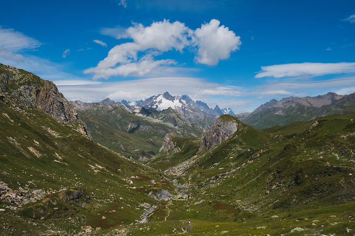
Europe’s highest mountain, Mt Blanc, with peaks capped by snow
-
Spellbinding views and wild open spaces
-
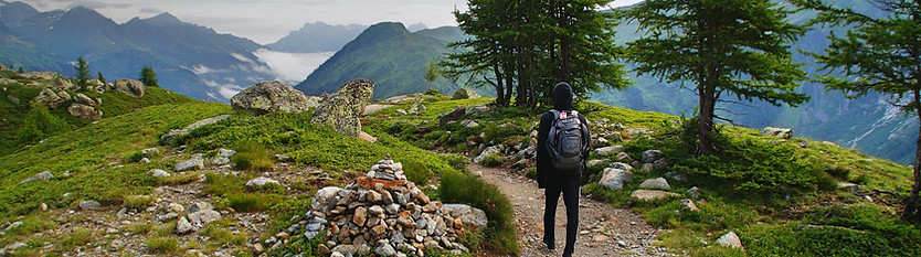
Walk through 3 countries - Italy, France and Switzerland
-
Warm, comfortable family-run mountain huts and small hotels
-
Rich and tasty mountain cuisine, including delicious cheeses, polenta, mushrooms
-
Friendly locals with a unique cultural heritage
-
Rich flora and fauna
Enjoy exhilarating hikes through a magnificent nature with stunning landscapes of dramatic snow-capped peaks, picture-perfect alpine pastures and idyllic meadows. Touring the Mont Blanc, Europe’s heighest peak you walk through 3 different countries France, Italy and Switzerland each with their unique architectonic styles and cuisine, a rich variety of wildlife including marmots and chamois, and an extraordinary variety of flowers which bloom in their thousands in spring and summer. The walks on well-marked trails are satisfyingly long but never exhausting.
You follow well-marked hiking trails, with the lettering TMB (Tour du Mont Blanc). The route indications are in red and white stripes In France and at altitude in Switzerland, and with a black diamond shape on a yellow background in the valley of Italy and Switzerland. The markings are in both directions; they are made with paint and are easily visible. These marks are placed regularly on trees, rocks, walls, and fences, etc.
The routes described here sometimes involve steep ascents and descents, but can be walked by a reasonably fit adult. Some stages are very long so we recommend always to carry enough food and water, and start off for the walks early in the morning. On some occasions there are optional opportunities for climbing local peaks; these are obviously more difficult trails, suitable only for experienced mountain hikers.
There are no technically difficult sections nor do they require scrambling, but the trip is not suitable if you suffer from a fear of heights as there are sections that could feel exposed
NOTE: You can book this trip with UPGRADED HOTELS in double room. Please check with us for price difference.

June - September
10 nights
XX
Start: Chamonix Goal: Chamonix
Day 1: Arrival Chamonix
Day 2: Chamonix t - Les Contamines ( 20.5 km)
Day 3: Les Contamines - Les Chapieux ( 15 km)
Day 4: Les Chapieux - Val Veny/Courmayeur ( 14 km, 19 km)
Day 5: Val Veny/Courmayeur - Val Ferret ( 5.5 km, 12 km)
Day 6: Val Ferret - La Fouly ( 18 km)
Day 7: La Fouly - Champex-Lac ( 18 km)
Day 8: Champex-Lac - Trient ( 15.7 km)
Day 9: Trient - Argentière ( 14.5 km)
Day 10: Argentiere - Chamonix ( 19.5 km, 17.5 km)
Day 11: Au revoir Chamonix
Day 1
Arrival at Chamonix

The trek starts in Chamonix: on your first day you can spend your day wandering through the streets of this lively city, do a little shopping in the many shops of the city centre or maybe spoil yourself with a visit to the spa.
Day 2
Chamonix to Les Contamines ( 20.5 km)

Today's walk starts with a bus from Chamonix to Les Houches, followed by the Bellevue cable car, up to 1800m. From here, instead of going up the "French normal route" of Mont Blanc (up to the Gouter hut at 3800m and to the summit at 4810m) you follow the edge of the mountain to Col de Voza and then start descending to the valley. Here you can see the typical local way of making roofs for mountain houses, with large flat stones. Later you go through several small villages on the valley floor with Mont Blanc peeking out again from the sky. The last part of the trail is along the Bon Nant river, to Les Contamines.
You then continue along an ancient Roman path and one of Europe's most famous trails, across blooming meadows and striking woodland to the refuge, a typical mountain chalet with a breath-taking view. Walkers are accommodated in small dormitories for between six to nine people and a hearty evening meal is served in the chalet's cosy dining room.
Challenge: 7 hours, 20.5 km, 987m ascent, 1094m descent
Day 3
Les Contamines to Les Chapieux ( 15 km)

Today's walk takes you through the Plan des Dames up to the Col du Bonhomme (2329m) then still a bit further up to the Col de la Croix du Bonhomme (2479m). You'll see a peculiar combination of stones marking the top of the pass from where you can admire the valleys stretching out for miles around you. From the pass you make a long descent through the open meadows of the Vallee des Chapieux, criss-crossing small brooks and passing mountain huts. At the bottom of the descent you reach the tiny village of Les Chapieux. Your accommodation tonight is a simple mountain hotel.
Challenge: 7 hours, 15 km, 900m ascent, 900m descent
Day 4
Les Chapieux to Val Veny/Courmayeur ( 14 km, 19 km)

Today is the longest and most demanding day of the holiday but definitely very scenic, with surprising landscapes all the way. After two days spent walking in France, today you go over the Col de la Seigne (2516m) and enter into Italy through the Val Veny. The day starts off with a climb through a deep gorge surrounded by vast pastures with lunar-like scenery as backdrop. The Col de la Seigne and the Aiguille des Glaciers mountains loom large in the distance on the border between Switzerland and Italy. Once over the top of the pass you descend into the Val Veny Valley on the opposite side of Mont Blanc, from where you can enjoy magnificent views of the snow-capped peaks.
Depending on avaibility, today you may be booked at a nice Rifugio in La Les Blanche or at Courmayeur: if you are booked here, you will walk 5,5 kilometres to reach a bus stop in La Visaille where you will take a bus to Courmayeur.
Challenge: 5/7 hours, 14/19 km, 1250/1500m ascent, 1180/1380m descent
Day 5
Val Veny/Courmayeur to Val Ferret ( 5.5 km, 12 km)
Today’s walk is divided into 2 parts; if you have slept in Rifugio Elisabetta, in the morning you will walk 5,5 km to the bus stop and descend towards the famous city of Courmayeur by bus. Courmayeur is a renowned ski resort where you can have a well-deserved rest before starting off again with a steep ascent followed by a level walk through meadows and conifer woods to Val Ferret, passing many small brooks, with the wonderful, awe-inspiring silhouette of the Grand Jorasses standing out. If you feel tired, or if you prefer to stroll through the streets of the centre, you can stop in Courmayeur and then take a bus directly to Val Ferret.
Challenge: 2.5/4.5 hours, 5.5/12 km, 300/900m ascent, 800/400m descent
Day 6
Val Ferret to La Fouly ( 18 km)

This morning's walk will take you up a steep ascent and past ruined farmhouses. This marks the start of your journey into Switzerland. The first 4 or so kilometres are a gradual 150m ascent along a surfaced road. If you wish, you can avoid this section by taking the SAVDA bus that stops in front of the hotel. From Waypoint 4 a steep and rewarding climb takes you to Rifugio Elena then on to the border crossing with Switzerland, at the top of the Col du Gran Ferret (2537m). The views of the receding Glacier and the perennial snow of Triolet and Pre de Bar are imposing. The descent is through vast open meadows with very few traces of human settlement. You pass a couple of mountain huts then nearing the small hamlet of Ferret and on to La Fouly, the trail passes through idyllic scenery of forests, creeks and picturesque wooden bridges. You spend the night in the village of La Fouly.
Challenge: 6 hours, 18 km, 870m ascent, 920m descent
Day 7
La Fouly to Champex-Lac ( 18 km)

After the efforts of the last few days, today offers you an easier walk. This section is quite long, but the elevation gains and losses are not so pronounced. Starting off from La Fouly, you follow the river encountering a succession of woods, interrupted by cliff walls and small streams. You then walk through meadows to reach Les Arlaches, a beautiful hamlet with many traditional wood and stone houses. The last stretch is up a long winding climb, it's not too steep and there are interesting wood sculptures along the way to look at. At Orsieres the trail descends to Champex-Lac, a pretty mountain village situated on the lake.
Challenge: 6 hours, 18 km, 700m ascent, 715m descent
Day 8
Vandring Champex-Lac to Trient ( 15.7 km)

A spectacular walk over the Fenêtre d'Arpette (2665m) from where you descend along the Glacier du Trient. Trient (1300m) is a village on the pass road from Martigny to Chamonix.
In bad weather, there is an alternative route, From Arpette to Trient via Champex-d'en Haut, through cool forests and beautiful alpine meadows that take you to Col de la Forclaz, which is an important link between Switzerland and France. This walk enjoys breathtaking panoramas and reaches 2050m.
Challenge: 7 hours, 15.7 km, 711m ascent, 1125m descent
Day 9
Trient to Argentière ( 14.5 km)

Today you'll get to have your last views of Mont Blanc and enjoy your final walk to Argentiere. You are above the ski resort of Le Tour from where you hike towards Lake Charamillon (2271 metres). You then continue on to the immense Glacier du Tour and back into France. An exhilarating rocky trail along the mountain crest allows you to enjoy astounding views of the glacier and the surrounding valleys. As you reach the border between Switzerland and France, you can see Mont Blanc shining white, especially on sunny and bright days. You descend among pastures for the last section of the walk until you arrive at Argentiere.
Challenge: 4 hours, 14.5 km, 985m ascent, 906m descent
Day 10
Argentiere back to Chamonix ( 19.5 km, 17.5 km)

The walk today is quite long so start early! You begin walking through the pretty little village Les Frasserands, with the typical wooden houses of the French alps. After going through the botanic path you start climbing uphill, into the Aiguilles Rouges Natural Park. You can decide if you want to continue to climb up to Lac Blanc (it involves the climb of an iron ladder, so if you suffer from vertigo you better not do that) or start descending to La Flegere. The route is very panoramic, in front of you the Mont Blanc massif, with the Aiguille Verte, the Drus, the Aiguille du Midi, Mont Blanc du Tacul and Mont Blanc, untill you arrive at Planpraz, where the cable car will take you down to Chamonix (last one is at 5 pm). If you are tired or in short of time you can also take the cable car at La Flegere.
Challenge: 8/7 hours, 19.5/17.5 km, 1623/1443m ascent, 971/789m descent
Day 11
Au revoir Chamonix

The trip and our services end after breakfast unless you have booked extra services or extra nights.
Practical information
You can start your travel any day of the week depending on availability between June and September.
If you travel by plane, the main airport you could flight in to reach the start of the Mont Blanc walking tour is Genève, in Switzerland.
Arrival in Chamonix
There is a regular bus service from Genève airport (GVO) to Les Contamines (www.sat-montblanc.com), trip can last from 1 hour 45 minutes to 2 hours 30 minutes; also possible is to prebook a private transfer (www.alpybus.com).
If you travel per train: There are regional train and TGV high-speed mainline train connections from St Gervais-le Fayet railway station, just 20km away. From there take the connection to Gare Chamonix – Mont Blanc.
The Mont Blanc Express: This SNCF railway line serves all villages from St Gervais-le Fayet to Martigny (Switzerland) via Servoz, Les Houches, Chamonix, Argentière and Vallorcine.
Information SNCF: www.voyage-sncf.com
All properties are carefully selected with a view to location, atmosphere and/or unique facilities. All rooms have a private bathroom. You can always book in advance for extra nights at one of the accommodations along the way.
GPS maps are available upon request
The price includes:
-
8 nights incl. half board
-
2 nights B&B
-
Detailed information, descriptions and maps for your trip
-
Telephone support 24/7
Not included:
-
Lunches
-
Tourist taxes
-
Travel insurence
-
Personal expenses such as drinks, tips, etc
-
Luggage transfer
Optional:
-
Single room supplement
-
Optional luggage transfer from one accommodation to the next